Executive Summary
In this section we highlight key results of this report
Preliminary Assessment
The Alberta Biodiversity Monitoring Institute (ABMI) measures and reports on the state of biodiversity and human footprint across Alberta. This report is a preliminary assessment of the status of land cover and biodiversity in Norbord Inc.'s (Norbord) two main operating areas in Alberta.
This information establishes baseline conditions for several indicators of land cover and biodiversity which can be used to measure long-term forest health and inform current and future adaptive management strategies in Norbord’s operating areas.
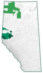
Area of Analysis
There are three areas of analysis included in this report:
- The Northern Operating Area is located in the northwestern corner of Alberta and covers an area of 39,168 km2; this area makes up 78% of Norbord’s total operating area in Alberta.
- The Southern Operating Area covers approximately 11,013 km2 representing 28% of Norbord’s managed landbase.
- The Partner Operating Area covers approximately 7,051 km2, in areas adjacent to the Southern Operating Area.
Methods
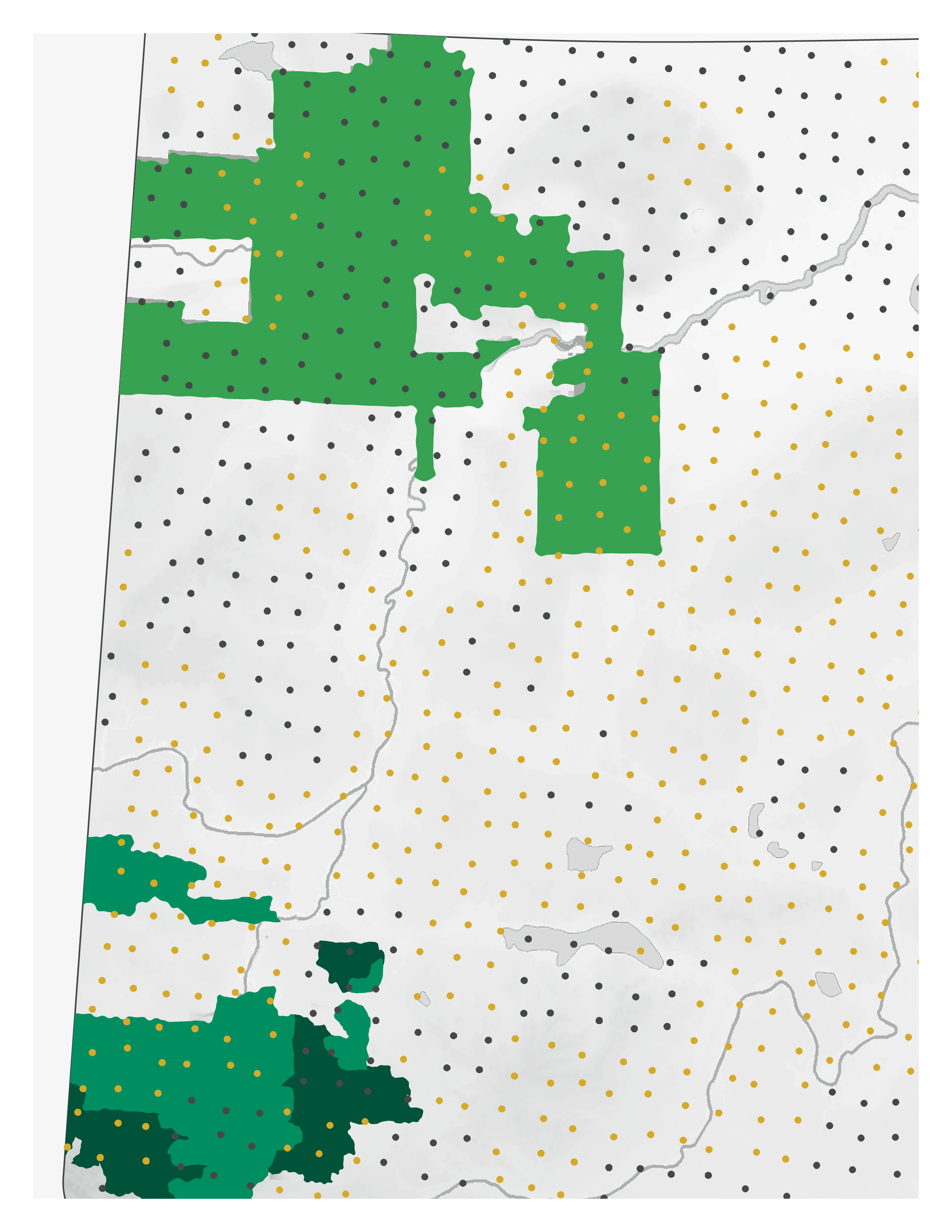
The ABMI has 120 permanent monitoring sites in Norbord's operating areas, including 95 sites in the Northern Operating Area and 25 sites in the Southern Operating Area; data has been collected at 53 of these sites to-date. At each location, ABMI technicians recorded the species present, and measured a variety of habitat characteristics.
The ABMI also measured human footprint using fine-resolution aerial photography and satellite imagery at two spatial scales. Detailed assessment of human footprint was completed using a 3 × 7 km area around each of the 120 permanent monitoring sites in 1950, 1980, and between 1999 and 2019. A broad assessment of human footprint was also conducted using a wall-to-wall human footprint map for the entire province circa 2018. Land cover and species data were used to assess the status of a number of indicators.
Human Footprint & Land Cover Results
Status & Trend in Human Footprint
As of 2018, the total human footprint was found to be 8.8% in the Northern Operating Area and 30.7% in the Southern Operating Area.
- Forestry was the largest human footprint in both operating areas, representing > 70% of human footprint in each area.
- Energy footprint (2.8%) and transportation footprint (1.8%) were the next most common footprint types in the Southern Operating Area. Energy (1.9%) was the next most common footprint type in the Northern Operating Area.
- The remaining footprint types each covered less than 1% of the region.
Between 2000 and 2019, the area of human footprint increased by:
- 17.8 percentage points, from 13.6% to 31.4% in the Southern Operating Area
- 4.8 percentage points, from 4.2% to 9.0% in the Northern Operating Area.


Linear Footprint
As of 2018, the density of linear features was:
- 3.23 km/km2 in the Northern Operating Area
- 3.43 km/km2 in the Southern Operating Area.
The predominant line types in both operating areas were conventional seismic lines, followed by roads.
Trend in Vegetation Types
In the Northern Operating Area, which is located entirely in the Boreal Forest Natural Region, 35.7% of the landbase is covered by forested stands; deciduous is the most common stand type at 23.8%, with white spruce (4.9%), mixedwood (4.7%), and pine (2.3%) each covering < 10% of the landbase.
The Southern Operating Area overlaps with the Foothills, Boreal Forest, and Rocky Mountain Natural Regions. Deciduous (29.8%) is the most common stand type, followed by white spruce (8.9%), mixedwood (7.8%), and pine (6.8%).
Northern Operating Area

Southern Operating Area

Interior Native Habitat
As of 2018, the status of interior native habitat was:
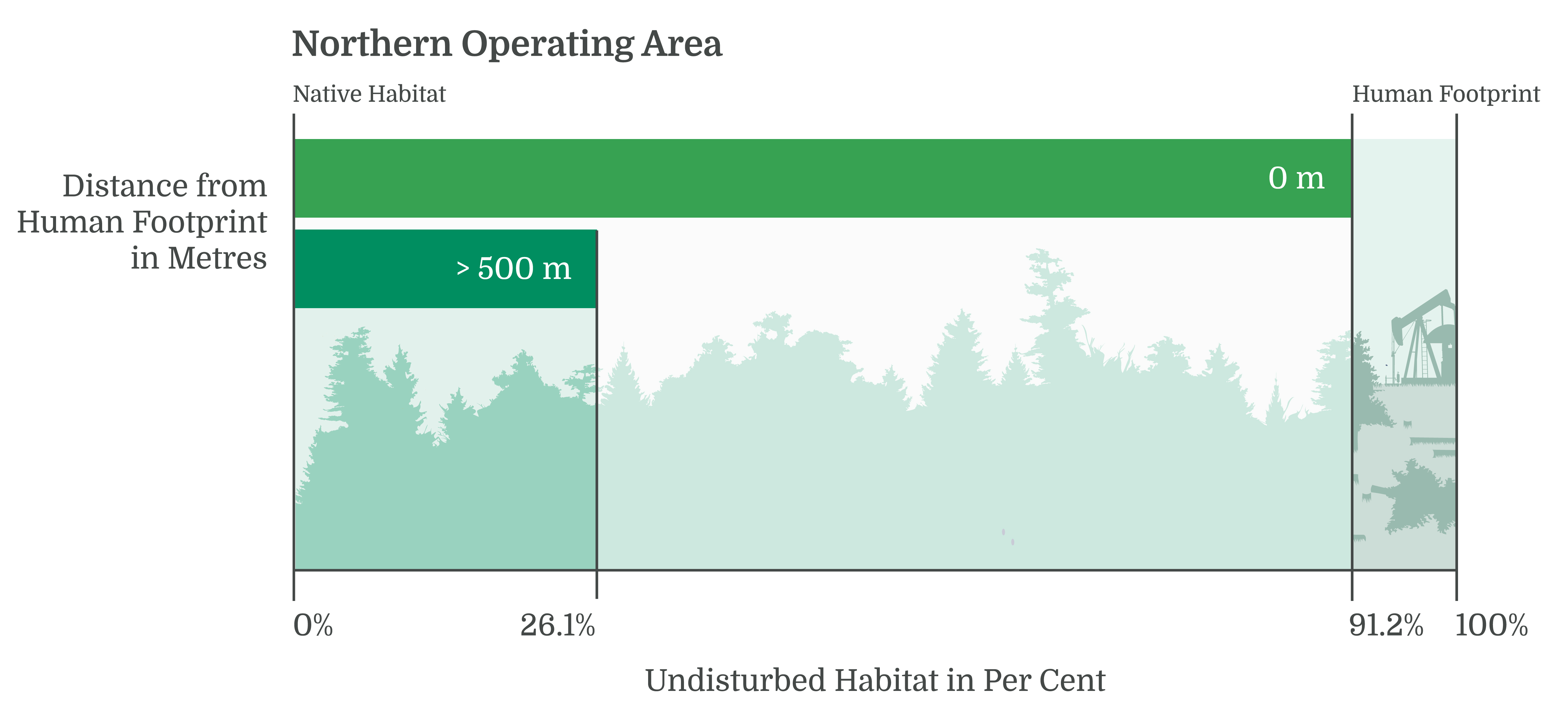
Northern Operating Area
Interior native habitat comprised 91.2% of the total landbase in the Northern Operating Area. When considering native habitat at least 500 m from human footprint, that figured dropped to 26.1%.
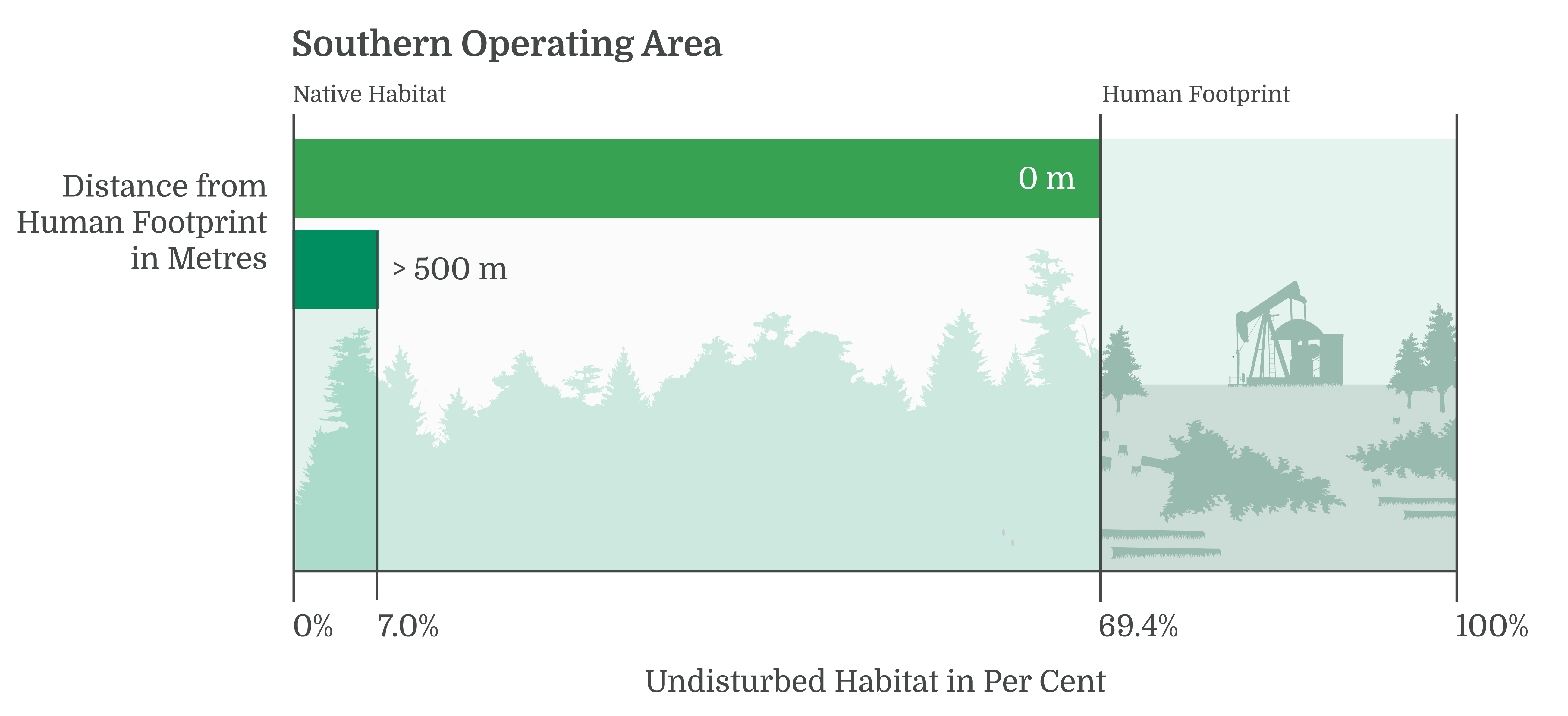
Southern Operating Area
Interior native habitat comprised 69.4% of the total landbase in the Southern Operating Area. When considering native habitat at least 500 m from human footprint, that figure dropped to 7.0%
Status of Biodiversity
Biodiversity Intactness
The ABMI assessed the status (current condition) of over 600 species in Norbord's operating areas and found the Biodiversity Intactness Index to be, on average, 94.9% in the Northern Operating Area and 85.8% in the Southern Operating Area.
Of the full suite of species assessed by the ABMI in this report, we profiled species associated with old deciduous and mixedwood forests for birds, mites, vascular plants, mosses, and lichen because Norbord's forestry activities disproportionately affect deciduous and mixedwood forest. Results for all mammal species are also shown.

Intactness by taxonomic group was found to be:
Sector Effects
At the local scale where human footprint occurs, most species associated with old deciduous and mixedwood forests are predicted to be less abundant than expected in all footprint types compared to in the habitat each footprint replaces. However, predicted population changes at the regional scale are small because the areas occupied by the different footprint types are generally small in Norbord's operating areas. Forestry footprint generally results in the largest predicted loss of suitable habitat for species associated with old forest because harvesting is the largest footprint type, and harvesting mostly occurs in old upland forest.
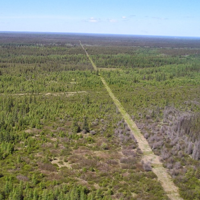
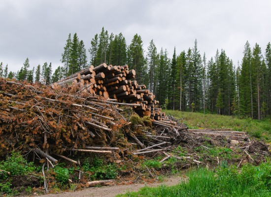 Photo: ABMI
Effects of Landbase Change on Habitat Elements and Birds
Landbase change between 2010 and 2018 was predicted to affect habitat elements and bird species across the Norbord landbase, with different types of change in the Northern and Southern Operating Areas.
Habitat Elements
- In the Northern area, with a shorter harvest history, the effects of new forestry generally outweighed any counteracting effects of regenerating older harvest areas with most habitat elements predicted to decrease in abundance.
- In the Southern region, new and old forestry changes tended to balance out more, except for habitat elements common in older stands (older than the harvest history in the area).
- Effects of landbase change on three specific habitat elements that are common in mature/old deciduous and mixedwood stands—large deciduous trees, large deciduous snags, and large fallen logs—were also examined. New forestry, and to a lesser extent fire, reduced the abundance of these elements but this decrease was largely offset by the aging of both harvested stands and stands originating from natural disturbance.
Birds
- In the Northern area, with a shorter harvest history, the effects of new forestry generally outweighed any counteracting effects of regenerating older harvest areas.
- Fire was also an important cause of change for many species in the Northern area, stronger than net forestry effects for some birds.
- In the Southern region, new and old forestry changes tended to balance out more, except for species only associated with older stands (older than the harvest history in the area), such as Canada Warbler and Black-throated Green Warbler.
- Effects of landbase change were also shown for four species including two species associated with old forest (Bay-breasted Warbler, Brown Creeper), one species associated with mid-age stands (Ovenbird), and one species associated with young harvested stands (Northern Flicker).
Additional Results
-
A total of 28 non-native vascular plant species were detected in Norbord's managed landbase; only six species were detected in the Northern Operating Area. Of the non-native vascular plants, two species are designated as Noxious Weeds under the Weed Control Act: Perennial Sow-thistle, which was detected at 8.8% of sampled sites in the Northern Operating Area, and Ox Eye Daisy, which as detected at 5.3% of sites in the Southern Operating Area. In the Northern Operating Area, non-native species were detected at 26.5% of sites with an average of 1.9 species per site. In the Southern Operating Area, non-native species were detected at 63.2% of sites with an average of 5.4 species per site.
- 18 designated species-at-risk were detected in Norbord's managed landbase. These species included ten bird species, five lichen species, two mammals, and one amphibian.
- Results for the fRI Grizzly Bear Research Program are highlighted, including important Grizzly Bear habitat and mortality risk in the Southern Operating Area.
- Density, habitat associations, and predicted relative abundance of Moose are presented. Overall, Moose populations are predicted to be more abundant than expected in the Southern Operating Area because the young harvested stands resulting from forestry activities improves habitat suitability.
This report is in partnership with